Thonis-Heracleion Sunken City: The Lost Port of the Pharaohs
The Thonis-Heracleion sunken city was long dismissed as an alluring classical fable before its monumental stone monuments were dragged from the sea floor. For over a millennium, scholars classified its existence alongside mythical realms, relying solely on tantalizing passages written by Herodotus and Strabo. Ancient accounts depicted a bustling metropolis presiding over the Canopic mouth of the Nile, where the Mediterranean world met dynastic Egypt.
According to myth, the demigod Heracles consecrated the city upon arriving on African soil. Paris and Helen of Troy sought political asylum within its sanctuaries while fleeing the wrath of Menelaus. Yet, centuries of conventional terrestrial expeditions across the western Nile Delta failed to unearth a single foundation stone. As coastal sands shifted, academics reasoned that Herodotus had conflated folklore with maritime reality.
That scholarly consensus shattered in the year 2000. Operating six miles off the modern coast of Alexandria, marine surveyors pierced through thirty feet of water and meters of protective silt. What emerged was not a modest trading post, but an immense maritime center of temples and wharves. The physical reality of the Thonis-Heracleion sunken city fundamentally reshaped modern understanding of ancient Mediterranean commerce.
The Rediscovery of the Thonis-Heracleion Sunken City in Aboukir Bay
The rediscovery required technological innovation rather than conventional excavation methods. French underwater archaeologist Franck Goddio initiated a meticulous geophysical survey across the expansive floor of Aboukir Bay in the late 1990s. Goddio recognized that centuries of silt deposits and seismic events had buried the ruins far beneath the seabed.
Conventional diving sweeps could never penetrate the dense marine clay. Instead, Goddio deployed nuclear resonance magnetometers mounted to marine vessels, cross-referencing spatial measurements with side-scan and multibeam sonar arrays. These instruments detected subterranean magnetic variations, charting geometric walls and structural alignments buried deep beneath the sand.
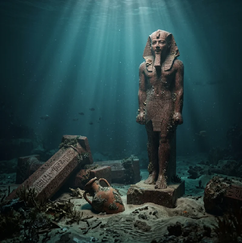
When divers descended into the turbid water to investigate the sonar targets, monumental architecture emerged from the gloom. Monolithic granite blocks, toppled ashlar walls, and intact stone staircases lay scattered across miles of underwater topography. Colossal statues of the goddess Isis, the Nile deity Hapi, and Ptolemaic royalty reclined in the silt like slumbering titans.
The marine environment had preserved what centuries of quarrying on land would have destroyed. The submerged ruins spanned more than four square miles, establishing the Thonis-Heracleion sunken city as an unparalleled underwater archaeological site.
[Archaeological Survey Specifications: Aboukir Bay Grid]
Survey Zone: Approximately 110 square kilometers across Aboukir Bay
Water Depth: 6 to 10 meters (20 to 33 feet) beneath current sea level
Sediment Cover: 1 to 3 meters of fine silt, marine sand, and clay
Primary Detection Tools: Nuclear resonance magnetometers, multibeam bathymetric sonar
Architectural Layout: The Venice of Dynastic Egypt
Archaeological cartography revealed that the Thonis-Heracleion sunken city was engineered as an intricate aquatic landscape. Built directly across low-lying coastal islands and shifting sandbanks, the city functioned as an interconnected matrix of canals, basins, and protective lagoons. Flat-bottomed barges and wooden skiffs ferried goods and citizens between neighborhoods.
Dwellings constructed from mud brick and timber sat on elevated earthen terraces, while monumental stone temples anchored the urban core. Interconnecting footbridges spanned the waterways, establishing a sophisticated flow of foot and river traffic. Wharves made of massive limestone blocks lined the main harbor basins, equipped with stone bollards to secure merchant fleets arriving from Greece, Phoenicia, and Cyprus.
[Urban Spatial Organization]
- Central Sacred Island: Dominated by the grand temple complex of Amun-Gereb
- Eastern Port Basin: Deep-water anchorage reserved for international trade ships
- Western Lagoon: Industrial zone housing shipwrights, metalworkers, and fish processing
- Residential Quarters: Network of canal-linked islands with multi-room domestic compounds
The scale of water management demonstrated astonishing hydraulic mastery. Canals served multiple purposes, carrying daily commerce, draining agricultural overflow, and accommodating sacred barque processions during religious celebrations. The water-bound architecture resembled contemporary settlements along the [Internal Link: Phoenician Maritime Trade Networks], which utilized offshore islands to shelter wealth from continental invasions.
Economic Hegemony and Customs Control at the Canopic Mouth
During the Late Period and the Ptolemaic Dynasty, between the sixth and fourth centuries BCE, the city enjoyed an administrative monopoly. Royal decrees designated it as the compulsory customs station for foreign merchant vessels seeking entry into the Nile interior. Every ship carrying Athenian olive oil, Chian wine, or Levantine timber had to anchor in its deep-water harbor.
Royal scribes and customs officials inspected manifests, levying heavy import tariffs on behalf of the pharaonic treasury and the priesthood of Amun. Archaeologists have recovered hundreds of bronze weights, lead sealings, and commercial stamps alongside Athenian tetradrachms and Persian silver coins. This tax revenue secured astronomical wealth for the governing elite.
Dredging operations inside the primary harbor basins yielded an extraordinary assembly of luxury merchandise:
-
Hundreds of intact Attic amphorae bearing traces of imported Aegean wines and resins.
-
Bronze situlae, ritual incense burners, and ceremonial ladles crafted for elite domestic use.
-
Delicate Athenian perfume vessels alongside alabaster unguent jars from the Levant.
-
Thousands of gold coins and decorative pendants lost along the busy quays.
The discovery of the decree of Saïs on a pristine black granodiorite stela confirmed the administrative status of the Thonis-Heracleion sunken city. Commissioned by Pharaoh Nectanebo I, the identical twin of a stela found at Naucratis explicitly outlined a ten-percent tax levied on all foreign maritime goods, with the revenue dedicated to the temple of Neith.
The Richest Ship Graveyard in the Ancient World
The harbor basins of the Thonis-Heracleion sunken city contain the highest concentration of ancient shipwrecks ever documented by maritime historians. Divers have mapped over seventy individual shipwrecks dating from the sixth to the second centuries BCE. Many of these hulls were not lost in open-sea storms; they were deliberately scuttled or trapped along collapsing wharves.
More than seven hundred iron and stone anchors have been pulled from the seabed, detailing centuries of frantic mooring maneuvers in shifting currents. The vessels themselves represent an encyclopedic repository of naval engineering. Shipbuilders constructed the local crafts using native acacia timber joined through mortise-and-tenon fastenings, reflecting Egyptian shipbuilding traditions described by Herodotus.
[Maritime Fleet Profile: Harbor Vessels]
Documented Shipwrecks: Over 70 individual hulls identified
Ship Classifications: Nilotic cargo barges, coastal freighters, sacred processional vessels
Dominant Timber: Local Acacia nilotica, reinforced with imported cedar ribs
Average Lengths: 14 to 28 meters with wide beams and shallow drafts
Associated Finds: 700+ iron and limestone anchors, lead sounding weights, rigging rings
The discovery of the sacred barque—a ceremonial vessel over fourteen meters in length—demonstrated how religion and seafaring intertwined. These vessels carried statues of Osiris and Amun across the canals during festival weeks. The underwater conditions preserved timber joints, internal decking, and cordage that would have decayed completely in oxygen-rich soil.
The Grand Temple of Amun-Gereb and the Divine Pharaonic Mandate
At the spiritual center of the city stood the monumental temple complex of Amun-Gereb. Dedicated to the supreme creator god and his divine consort, the sanctuary served as an ideological engine for dynastic legitimacy. Pharaohs traveled to this site to receive their divine titles and confirm their authority before ascending the throne of unified Egypt.
Within the temple perimeter, archaeologists discovered monumental statues of pink Aswan granite soaring over five meters in height. These sculptures depicted the god Hapi, the divine guarantor of the Nile inundation, alongside figures of Ptolemaic monarchs sculpted in traditional pharaonic regalia. The temple functioned as a repository of sacred wealth, housing gold votive bowls, bronze statuettes, and miniature shrines.
Priests conducted complex annual rites celebrating the resurrection of Osiris. During the sacred month of Khoiak, temple initiates transported effigies of Osiris along the city’s canals in boat processions, traveling from the temple of Amun to the sanctuary of Osiris at neighboring Canopus. The rituals tied the natural cycles of agricultural abundance directly to the stability of the crown. The surviving artifacts from these temples shed light on the ritual practices of [Internal Link: The Ptolemaic Dynasty and Temple Economy], showing how Greek rulers embraced indigenous religious institutions to cement power.
The Cataclysm: Soil Liquefaction and the Disappearance of the City
How did an entire stone metropolis vanish into the sea? The destruction was not caused by foreign bombardment or municipal abandonment. The ultimate catalyst was the delicate geology beneath the foundations.
The city rested on a network of water-saturated sandbanks and soft marine clay at the mouth of the Nile. Modern geological coring indicates that during the late eighth century CE, a devastating sequence of tectonic shocks struck the eastern Mediterranean. These seismic waves originated along the Hellenic arc, triggering a geotechnical catastrophe known as soil liquefaction.
[Catastrophic Mechanism: Soil Liquefaction Timeline]
1. Prolonged Tremors: High-magnitude seismic shocks rock the western Nile Delta.
2. Pressure Spikes: Pore-water pressure within saturated silt and sand rises abruptly.
3. Structural Collapse: Interlocking grain cohesion fails; soil transforms into a viscous fluid.
4. Foundation Failure: Colossal granite statues and stone walls sink into liquefied mud.
5. Inundation: Tsunami backwash and rising waters permanently drown the submerged island tracts.
The sheer mass of the monumental architecture hastened the collapse. The ground could no longer support the weight of limestone pylons and granite statues. Within hours, entire harbor islands collapsed, sliding into the lagoons as the ground turned to slurry.
Simultaneous tsunami waves generated by the offshore tremors swept over the delta, carrying sand and silt that filled the harbors. The waters claimed what remained, leaving the Thonis-Heracleion sunken city submerged beneath the waves of Aboukir Bay for over twelve hundred years.
Technical Specifications: Arms, Armor, and Artifact Catalog
Excavation across the primary harbor sectors has retrieved an astonishing variety of weapons and industrial metalwork. Greek mercenaries and royal marine guards left behind clear physical evidence of their presence throughout the administrative district.
-
Bronze Spearheads: Leaf-shaped points measuring 28 to 38 centimeters in length, cast with reinforced midribs designed to penetrate composite lamellar armor.
-
Hoplite Swords (Xiphos): Double-edged iron blades recovered from harbor silt, averaging 50 to 60 centimeters in length, showing evidence of bone-inlaid hilts.
-
Corinthian Helmets: Heavy cast-bronze helmets featuring elongated cheekpieces and nose guards, hammered from single metal sheets.
-
Egyptian Battle Axes: Bronze crescent-shaped socketed blades secured to timber shafts with leather thongs, measuring 15 to 22 centimeters across.
-
Scale Armor Plates: Pierced bronze and iron platelets linked with sinew, averaging 4 by 2 centimeters, offering flexible defense for marine infantry.
These military remains demonstrate that the city was heavily fortified. Customs officials operated alongside professional garrisons, prepared to defend the vital delta choke point against pirate incursions and foreign fleets.
Archaeological Value of the Thonis-Heracleion Sunken City
The recovery of this maritime metropolis has revolutionized maritime archaeology. Unlike terrestrial sites, where successive generations demolished ancient buildings to repurpose stones, the submerged ruins were sealed beneath a layer of protective silt. The seabed preserved perishable materials, including textiles, wooden tools, and papyrus scrolls, that would have disintegrated elsewhere.
The site provides an unbroken stratigraphic record spanning from the twilight of pharaonic independence through the height of the Hellenistic era. Historians can track how Greek merchants gradually integrated into Egyptian society, creating a hybrid culture long before Alexander the Great marched into Memphis.
Scholars now understand that the Nile Delta was far more interconnected with the broader Mediterranean world than previously believed. The Thonis-Heracleion sunken city proves that ancient Egypt was not an isolated land, but a dynamic seafaring power whose trade networks anchored classical antiquity.
Frequently Asked Questions
What caused the Thonis-Heracleion sunken city to disappear beneath the sea?
The city sank due to localized soil liquefaction triggered by severe earthquakes and tidal waves during the late eighth century CE. The soft sand and clay supporting heavy stone temples lost its structural stability, causing the islands to collapse into the sea.
How was the city discovered after being lost for centuries?
Archaeologist Franck Goddio discovered the site in the year 2000 using marine magnetometers, multibeam sonar, and bathymetric mapping. The instruments penetrated meters of sea sediment in Aboukir Bay, revealing hidden stone foundations beneath thirty feet of water.
Why was Thonis-Heracleion so important to ancient Egypt?
It served as the mandatory customs port of entry for all foreign ships trading through the western Nile Delta between the sixth and fourth centuries BCE. It dominated international trade and served as a major religious center where pharaohs legitimized their divine rule.