
Ancient Nazca Culture: Secrets of the Sacred Desert Geoglyphs
The ancient Nazca culture flourished across the hyper-arid plains of southern Peru between roughly 100 BCE and 800 CE. Long before modern aviation exposed the immense geoglyphs etched into the pampa floor, this pre-Columbian society developed complex agricultural systems and enduring communal rituals beneath the shadow of the Andes.
Rather than relying on extraterrestrial intervention or lost technologies, the ancient Nazca culture solved real environmental threats through practical engineering and religious ritual. Confronted by chronic drought, shifting riverbeds, and fragile desert topsoil, their artisans carved colossal animal figures, trapezoids, and miles of dead-straight paths directly into the desert crust.
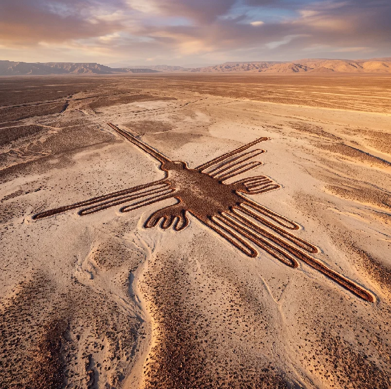
Hummingbird geoglyph in the Nazca desert. Source: DanielPrudek / Getty Images
The Landscape: Engineering Life on the Pampa
The coastal basin of Rio Grande de Nazca sits wedged between the Pacific Ocean and the steep western slopes of the Andes. Cold Antarctic currents along the coast prevent coastal cloud condensation, while the rain shadow of the Andes blocks Atlantic moisture. Rain falls across the desert floor for less than an hour across an entire calendar year, creating a hyper-arid strip of desert pavement.
This extreme environment preserved the material legacy of the ancient Nazca culture for over two millennia. The ground consists of alluvial gravel coated in dark desert varnish, a thin veneer of iron and manganese oxides oxidized by baking heat and morning dew.
Beneath this sun-darkened stone layer lies pale, unweathered silt rich in calcium carbonate and clay. By removing the darker pebbles and stacking them neatly along trench borders, local workers created high-contrast lines that remain visible from surrounding hills and passing aircraft today.
       [Sunlight & Extreme Heat]
                   │
                   ▼
  ┌──────────────────────────────────────────────────┐
  │ Dark Pebbles / Iron-Oxide Desert Varnish (Layer) │  ◄── Cleared Surface
  ├──────────────────────────────────────────────────┤
  │ Pale, Calcified Silt & Clay Subsoil (Base)       │  ◄── Exposed White Line
  └──────────────────────────────────────────────────┘
The wind patterns across the plateau form a natural protective shield. The dark gravel absorbs solar energy during peak daylight hours, creating a warm thermal cushion of air that hovers several inches above the ground, deflecting harsh offshore trade winds away from the shallow trenches.
Origins and Evolution: From Paracas Roots to Nazca Dominance
The artistic traditions of the ancient Nazca culture did not emerge in isolation. They inherited the cultural and technological frameworks established by the earlier Paracas civilization, which inhabited the nearby Pisco and Ica valleys from 800 to 100 BCE.
Paracas weavers produced intricate polychrome textiles buried in arid shaft tombs, showcasing supernatural flying figures, feline predators, and severed trophy heads. Over generations, these textile motifs migrated from woven alpaca fibers onto coastal ceramics and eventually onto the open desert floor.
[Paracas Culture (800–100 BCE)]
  │
  ├── Dynamic Hillside Relief Geoglyphs (Visible from Ground)
  ├── Polychrome Textiles & Necropolis Burials
  └── Severed Trophy Head Iconography
  │
  ▼
[Ancient Nazca Culture (100 BCE–800 CE)]
  │
  ├── Vast Valley Floor Etchings (Single-Line Drawings)
  ├── Slip-Painted Polychrome Ceramics (Up to 13 Pigments)
  └── Monumental Ceremonial Center at Cahuachi
During the transitional phase around 200 BCE, the ancient Nazca culture changed the physical scale of these artworks. While Paracas artisans carved smaller relief figures on sloping hillsides so they could be viewed from settlement valleys below, Nazca builders shifted their focus to the broad desert floor (pampa).
These low-valley projects evolved from figurative creatures—spiders, hummingbirds, monkeys, and orcas—toward colossal geometric layouts. Over hundreds of square kilometers, vast trapezoids, triangles, and intersecting lines transformed the plateau into an open-air ceremonial landscape.
Surveying Without Flight: The Geometry of the Ancient Nazca Culture
Sensationalist claims often argue that the lines required aerial guidance to design. Archaeological excavations conducted across the pampa provide clear evidence of practical land-surveying methods.
Researchers from the Pontifical Catholic University of Peru recovered wooden posts, braided cordage made from plant fibers, and stone markers buried at line intersections. Radiocarbon dating confirmed that these surveying posts were placed during the height of the ancient Nazca culture.
[Small-Scale Model Sketch] ──► (Ceramic Shard or Packed Clay)
                                      │
                                      ▼  (Proportional Scaling)
[Baseline Rope & Center Stakes] ──► (Anchored in Ground)
                                      │
                                      ▼  (Radius Swing & Offsets)
[Offset Pegs] ──► [Continuous Removal of Oxidized Gravel]
The construction process was entirely earthbound, using simple geometric scaling:
-
Grid Proportions: Surveyors sketched small-scale templates on textile fragments, clay tablets, or small patches of ground, dividing the illustration into proportionate units.
-
Anchor Stakes and Sightlines: Teams placed wooden stakes into the ground, running straight lines across miles of desert by lining up three visual stakes along a flat horizon.
-
Compass Curves: Artisans created curved arcs, such as the spiraling tail of the monkey or the wings of the condor, by tying cords of fixed length to a center post and scribing matching arcs in the dirt.
-
Manual Removal: Labor brigades swept along the staked paths, picking up the dark iron-stained stones by hand and placing them along the outer rim to reinforce the visual edge.
To understand how other ancient empires coordinated heavy labor to manipulate stone, examine our study on the [Internal Link: Argead dynasty sarissa phalanx logistics] to see how state-level mobilization shaped the ancient Mediterranean.
Hydraulic Ingenuity: The Spiral Puquios
The artistic accomplishments of the ancient Nazca culture were secondary to their survival needs. The coastal valleys relied on seasonal runoff from the Andes, but riverbeds often ran dry for years during extended droughts.
To secure a permanent water supply, Nazca hydraulic engineers tapped into high mountain aquifers using puquios—subterranean aqueducts that remain an engineering marvel of pre-Columbian America.
       [Natural Ground Level]
                 │
                 ▼  (Spiral Funnel: "Ojo")
    @@@@@@@@@@@@@@@@@@@@@@@@@@@@@@@@@@  ◄── Open Air Vent & Terrace Step
   @                                @
  @   [Stone-Lined Subterranean]     @
 @             [Gallery]              @
═════════════════════════════════════════  ◄── Underground Water Table
These water networks were not simple ditches; they were cut deep into the subterranean water table:
Spiral Access Funnels (Ojos)
Engineers dug spiral, stone-lined funnels leading down from the desert surface into the subterranean channels. These stepped, funnel-shaped entrances allowed wind to flow into the conduits, generating pressure differentials that pushed water through the low-gradient galleries.
Masonry Channel Architecture
Subsurface channels were reinforced with river cobbles and split fieldstones, held together without mortar. Roofs were supported with cured trunks of the native huarango tree (Prosopis pallida), an extremely dense, rot-resistant wood capable of withstanding moisture and subterranean earth pressure for centuries.
Surface Reservoirs (Cochas)
The underground channels fed into open-air stone retention basins, storing mountain water for distribution through irrigation networks to agricultural fields of maize, beans, squash, and cotton.
Archaeological analysis reveals that the layout of the desert geoglyphs matches the subterranean courses of these water sources. Many straight lines converge on natural springs, river junctions, or subterranean fault lines where water pooled beneath the gravel, demonstrating that the artworks functioned as an aerial map of life-giving water.
[Andean Mountain Snowmelt]
            │
            ▼  (Subterranean Flow Through Porous Strata)
[Puquios System: Stone Masonry Galleries]
            │
            ├── (Ventilated by Spiraling "Ojos")
            ├── (Reinforced with Huarango Wood Lintels)
            │
            ▼
[Agricultural Cochas (Reservoirs)] ──► [Cotton, Maize, & Bean Fields]
Rituals, Processions, and Water Cults
For decades after commercial flights revealed the lines, researchers debated their primary function. German mathematician Maria Reiche spent nearly fifty years surveying the desert floor, suggesting that the lines functioned as an astronomical calendar aligned with planetary positions and solstices.
While some line systems track winter and summer solstices, modern multi-disciplinary excavations led by the German Archaeological Institute and Peru’s Ministry of Culture point toward water cult rituals.
[Communal Procession in Single File]
                 │
                 ▼  (Soil Compaction Along Trench Floor)
[Offerings: Spondylus Shells & Broken Polychrome Ceramics]
                 │
                 ▼
[Appeasement of Mountain Deities: Petitions for Aquifer Flow]
Field excavations reveal that the lines were not static designs meant to be viewed from above. They served as processional pathways:
-
Compacted Floor Chemistry: Soil tests show that the bottom of the cleared trenches is significantly more compacted than the surrounding, undisturbed desert. This density proves that generations of people walked along the lines in single-file religious processions.
-
Spondylus Offerings: Excavations at line terminals revealed smashed ceramic vessels and fragments of Spondylus princeps (thorny oyster) shells. Imported from warm equatorial waters off modern-day Ecuador, Spondylus shells were valued more than gold throughout Andean antiquity, used exclusively to summon rain from mountain deities.
-
Water Iconography: The biomorphic animals etched into the desert carry deep fertility symbolism in Andean mythology. The spider was associated with rain; the hummingbird symbolized pollinated crops and river runoff; the pelican was tied to coastal currents.
Walking the lines was a communal petition to the mountain deities. As drought gripped the valley, communities walked these sacred animal shapes to plead with ancestral spirits to keep the underground aquifers flowing.
To discover how another ancient civilization managed complex civic infrastructure, explore our detailed analysis of the [Internal Link: Achaemenid Persian Empire Royal Engineering] to compare early municipal planning across antiquity.
Cahuachi: The Pilgrimage Capital
The social heart of the ancient Nazca culture lay at Cahuachi, a monumental ceremonial complex located in the Nazca River valley. Covering over 150 hectares, the site features more than forty earthen mounds, terraced plazas, and pyramidal platforms made from conical mud adobes.
Excavations led by Italian archaeologist Giuseppe Orefici confirmed that Cahuachi was not a residential city. It operated as a non-urban pilgrimage capital where communities assembled for seasonal religious ceremonies:
-
Low Domestic Rubbish: The site lacks the thick debris layers of food bones, everyday pottery, and domestic ash typical of ancient cities.
-
Vast Ceremonial Architecture: The mounds incorporate tiered mudbrick walls, plazas, and sunken courtyards designed to accommodate thousands of pilgrims arriving from distant valleys.
-
Textile Offerings and Burials: Deep storage caches at Cahuachi held hundreds of fine, multi-colored textiles, musical panpipes (antaras), and elite burials of priests wrapped in embroidered mortuary bundles.
[The Temple Mound of Cahuachi]
  ├── Non-Urban Pilgrimage Capital (150 Hectares)
  ├── 40+ Earthen & Conical-Adobe Mounds
  ├── Center for Musical Rituals: Terracotta Panpipes (Antaras)
  └── Depository for Mortuary Bundles and Trophy Heads
Pilgrims journeyed to Cahuachi carrying ceramic offerings, ceremonial textiles, and mummified trophy heads. After gathering in the central plaza, these groups marched outward onto the desert plateau, walking the lines to reaffirm social ties and pray for rain.
Material Culture: Polychrome Ceramics and Iconography
The ancient Nazca culture produced some of the most vibrant pottery in the pre-Columbian Americas. Unlike the neighboring Moche culture of northern Peru, who emphasized realistic sculptural modeling, Nazca potters specialized in surface color and intricate painted designs.
Using slips mixed from mineral pigments, Nazca potters painted up to thirteen distinct colors on a single vessel, firing them in oxygen-rich kilns to produce bright, glossy finishes.
                  [Nazca Ceramic Evolution]
                             │
     ┌───────────────────────┼───────────────────────┐
     ▼                       ▼                       ▼
[Early Nazca (100–300 CE)] [Middle (300–500 CE)]   [Late Nazca (500–750 CE)]
• Naturalistic animals     • Mythical Beings        • Disordered imagery
• Clean slip paintings     • Severed Trophy Heads   • Warfare & drought icons
• Smooth double-spouts     • Intricate rays & masks • Abstract militarism
The ceramic sequence tracks the rising environmental pressures that faced the civilization:
-
Early Phase (Naturalistic): Vessels featured clear depictions of birds, fish, plants, and fruit, reflecting an era of agricultural stability.
-
Middle Phase (Proliferant): Imagery became surreal and mythic, featuring the Anthropomorphic Mythical Being—a composite creature with a feline face, feathered cape, and human hands gripping daggers and trophy heads.
-
Late Phase (Disordered): As droughts worsened and resources dwindled, ceramic designs turned dark, crowded with severed heads, weapons, and military commanders locked in combat.
Trophy heads were a central focus of Nazca religious life. Archaeologists have recovered caches of human skulls with holes drilled through the front of the forehead to hold carrying ropes.
Far from simple battlefield trophies, bioarchaeological testing shows these heads belonged to members of the local population, harvested during ceremonial rituals to release vitality back into the dry soil.
Environmental Collapse and Cultural Decline
The demise of the ancient Nazca culture offers a stark case study in environmental vulnerability. By the sixth century CE, recurring El Niño–Southern Oscillation (ENSO) weather patterns triggered catastrophic environmental shifts along the Peruvian coast.
The immediate cause of ecological collapse was severe deforestation:
[Deforestation: Clearing Huarango Forests]
                  │
                  ▼  (Loss of Deep Taproot Ground Anchors)
[Catastrophic El Niño Rainfall & Flash Floods]
                  │
                  ▼  (Unanchored Topsoil Washes Away)
[Irrigation Canals Destroyed & Agricultural Base Ruined]
Generations of farming communities cleared vast swaths of slow-growing huarango forests across the river valleys to open land for maize and cotton crops.
The huarango tree was the ecological keystone of the desert valley:
-
Soil Stabilization: Deep taproots, reaching up to fifty meters down, anchored alluvial topsoils against desert wind and flood erosion.
-
Moisture Retention: Fallen leaves enriched the arid earth with nitrogen while shading the ground to reduce moisture evaporation.
When extreme El Niño events struck around 550 to 600 CE, heavy rainfall swept down from the western Andes. Without the root systems of the huarango trees to stabilize the valley floor, flash floods tore through the river basins, washing away topsoil, ripping out stone irrigation channels, and burying agricultural fields under gravel.
Faced with crop failures, internal conflict, and ruined irrigation channels, communities dispersed. By 750 to 800 CE, the regional ceremonial center of Cahuachi lay abandoned, and the expanding Wari Empire absorbed the surviving population, ending a distinct cultural chapter on the pampa.
Preservation Challenges and the Aerial Renaissance
The desert artworks of the ancient Nazca culture remain fragile. While they survived millennia of wind and sun, modern human activity poses continuous threats:
-
Infrastructure Expansion: Construction of the Pan-American Highway directly through the heart of the Nazca plateau severed several linear geoglyphs before protective measures were established.
-
Illegal Squatting and Off-Road Traffic: Illegal mining operations, land squatters, and off-road vehicles frequently leave wheel ruts in the delicate crust, permanently damaging the exposed gravel lines.
-
Climate Pressures: Global climate changes have increased rainfall in the foothills, causing surface runoff that cuts gullies through geometric figures.
Modern Archaeological Technologies:
├── Deep Learning / Artificial Intelligence (AI) Models
├── High-Resolution UAV Photogrammetry & LiDAR
└── Satellite Multispectral Imaging
Archaeologists have simultaneously entered an era of discovery across the pampa. Teams from Yamagata University in Japan, partnering with IBM, use artificial intelligence to scan high-resolution aerial imagery and drone data.
These algorithms identify subtle landscape shifts that are invisible to the naked eye. In recent years, researchers uncovered hundreds of small geoglyphs carved on hillside slopes, depicting domestic camelids, human figures, and ritual dances.
These discoveries reveal that the lines were not isolated monuments, but part of a continuous sacred landscape linking domestic communities, ceremonial pilgrimage centers, and mountain shrines.
The ancient Nazca culture left behind a remarkable record of human ingenuity. Through calculated engineering, community organization, and profound respect for their desert ecosystem, they created an open-air sanctuary that still speaks across the desert floor.
Frequently Asked Questions
What was the ancient Nazca culture?
The ancient Nazca culture was a pre-Columbian civilization that flourished along the river valleys of southern Peru from approximately 100 BCE to 800 CE. They are renowned for their polychrome slip ceramics, complex underground aqueducts called puquios, and the creation of hundreds of colossal desert geoglyphs across the Nazca pampa.
How did the ancient Nazca culture make the Nazca Lines?
Artisans created the geoglyphs using simple subtractive techniques. Workers removed the dark, iron-oxide-coated pebbles that formed the desert floor to expose the pale, calcified silt underneath. By using central surveying stakes and scaling proportional designs with braided plant ropes, they laid out geometric lines and animal figures without needing aerial support.
Why did the ancient Nazca culture build the lines?
Archaeological evidence demonstrates that the geoglyphs served as ceremonial pathways and open-air temples tied to water and fertility rituals. Rather than viewing the images from the sky, people walked along the lines in single file, offering prayers, Spondylus shells, and ceramics to mountain deities to maintain underground water flows during severe regional droughts.